Activities
Activities include A Spatiotemporal Knowledge World and Transportation Networks.A Spatiotemporal Knowledge World
Space and time are used in an increasing number of applications as
the
primary means to structure and access information simply because
spatiotemporal (ST) reasoning is the most basic form of human cognition
for real world problem solving.
The aim is to harness the ability humans have to massively collectand share knowledge (i.e., consider blogging and other Web2.0 phenomena) for the ST domain to ultimately digitize the world using naïve methods. As early maps were traces of people’s movements in the world, i.e., view representations of people’s experiences, digitizing the world in this context relates to collecting pieces of knowledge gained by a human individual tied not only to space and time, but also to her context, personal cognition, and experience. Through intentional (e.g., geo-wikis, geocoding photos) or unintentional effort (e.g., routes from their daily commutes), simple users create vast amounts of data concerning the real world that contain significant amounts of information. Crowdsourcing, a term originally coined to describe collaborative knowledge creation and sharing in the Web (e.g., Wikipedia), is rapidly expanding in the spatiotemporal domain.
The ambitious aim in a ST crowdsourcing effort will be however to go beyond purposefully contributed data and to include any type of available content such as existing Web pages in the ST data collection effort. This potentially vast amount of data will lead to a digitized ST world beyond mere collections of co-ordinates and maps.
Achievements
GEOCROWD Geoblogging Platform (http://www.geocrowd.org)
One cannot deny that space and time are important to us. We perceive our world with respect to where and when we do things. We advocate geoblogging as a tool to capture such experiences by means of collecting and organizing images, audio, video and text in relation to space and time. This demo showcases a Web application that allows for a simple upload of content, geocoding, and map-based authoring of geoblogs. Export capabilities free the created content from a specific application context and allow for sharing and use of geoblogs in other applications, publications or social networking services.
When coming home from a memorable journey, wouldn’t it be great to create a digital replica of the trip, i.e., quickly organize collected images, videos, etc. and have a simple means of adding some thoughts? Should you be using Web 2.0 services such as Flickr, Picasa, etc. you might notice that such applications are data oriented. They provide for an efficient means of storing a specific type of content, including some limited content management functionality such as geocoding and grouping.
With our application, termed "Geocrowd", we propose geoblogging as a means for spatiotemporal storytelling, more specifically the story of a journey, be it an afternoon walk in your neighbor- hood, a chase for a great coffeeshop, your mountainbike trip, or hiking adventure. The scope is to provide a simple to use application that allows one to tell the story of the trip based on the content collected during the trip. The role of content is to support the story. In our application, the essential aspects are a map, a storyboard and a timeline.
We see geoblogging as a means to harness the ability humans have to massively collect and share knowledge (i.e., consider conventional blogging and other Web 2.0 phenomena) for the spatiotemporal domain. The ultimate goal will be to digitize the world using such user contributed content. As early maps were traces of people’s movements in the world, i.e., view representations of people’s experiences, digitizing the world in this context relates to collecting pieces of knowledge gained by a human individual tied not only to space and time, but also to her context, personal cognition, and experience.
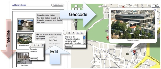
GEOCROWD interface and funcationality
Publications
- Geoblogging: user-contributed geospatial data collection and
fusion - Link
- Geospatial Route Extraction from Texts - Link
- Providing Universal Access to History Textbooks: A Modified GIS Case - Link
- Mobile Task Computing: Beyond Location-based Services and Ebooks - Link